3 Ways Satellite Imagery Can Help Restore the Great Barrier Reef
Satellite Imagery as well as a data management platform are invaluable assets to address complex ecological challenges and enhance our ability to make decisions for a sustainable future.
.png)
Queensland is home to 3 of the 7 natural wonders in Australia, one of which is: The Great Barrier Reef.
The Great Barrier reef extends 2,300 Kilometres along the coast of Queensland. It consists of the Great Barrier Reef Marine Park, established in 1975, and has been listed as a world heritage site since 1981. The reef is the largest living structure in the world and is visible from space. With a structure so expansive, it plays a vital role in the ecology and the economy of surrounding marine and terrestrial areas. Unfortunately, the Great Barrier Reef is at risk of disappearing.

The Great Barrier Reef ecosystem consists of 3000 individual reefs. These reefs are home to 25% of all known marine species including fish, birds, sharks, whales, and corals. The reef plays a vital role in connecting communities and people to the natural world. The beauty and biodiversity makes it a popular destination for tourism and is significant to the aboriginal communities within the Great Barrier Reef catchment. The reef supports 64,000 jobs in industries such as tourism, research, fishing, and education.
Unfortunately, due to climate change and polluted waters, the Great Barrier Reef is struggling. Most notably, is mass coral bleaching. Since 2016, there has been increased stress on the coral populations throughout the Great Barrier Reef, resulting in the corals expelling the algae that symbiotically lives with them and gives the corals their colour. While corals can survive bleaching, the loss of the algae makes the corals more susceptible to other stressors. One of these stressors is increased sediment, nutrients and contaminants in runoff from developed and rural areas within the Reef catchment, altering the quality of the water. In addition, climate change has affected the temperature, pH, and salinity. With species loss resulting from the bleaching and these additional stressors, it has allowed for disproportionate populations of pest species, such as the Crown of Thorns Starfish, to thrive. This has further resulted in damage to the Great Barrier Reef ecosystem.
Satellite Imagery as well as a data management platform such as Geostack Terra are invaluable assets to address complex ecological challenges and enhance our ability to make decisions for a sustainable future. Here we will explore 3 ways that satellite imagery can be used to help restore the Great Barrier Reef:
1. Identify Areas at Risk
Monitoring these changes is essential. With satellite imagery, public and private organisations within the environmental industry and government can map and evaluate the status of the reef to enact conservation techniques. The infrared bands and sensors can provide thermal imagery to observe changing sea surface temperatures. This information can be used in conjunction with other observational techniques to pinpoint areas where bleaching is most severe or predict where it could occur in the future. Red, Green, and Blue visible light bands can be used to produce a coloured image that can help identify structural changes in the reef system and observe bleaching patterns. On demand satellite imagery can provide frequent and up to date data and observations which can easily be inputted into GIS software and in turn help to develop policies and plans to restore and protect the reef. Satellite imagery provides a non-invasive technique to observe natural areas. By reducing the need for people or boats to enter these environments to make observations, further benefits the health of the reef ecosystem and limits disruptions to the wildlife during the restoration process.
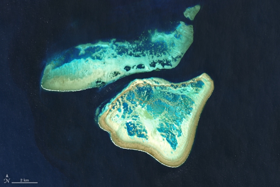
Great Barrier Reef, Landsat 8 – OLI, 2020
2. Monitor Land Based Activities
Thankfully, there are already several policies in place and organisations are working to restore and protect the reef. One goal is to reduce the land based impacts that are affecting the water quality. This progress can be monitored using satellite imagery. High quality satellite imagery has proven to be a useful tool in monitoring construction projects, residential land management, and enforcing regulation. With frequent visits, regular imagery can ensure that all development and agriculture operations are reef friendly. Any improvements or worsened characteristics of the watershed can be monitored using high quality satellite imagery. This information can then be used to encourage the changes that are helping or to rework the methods currently in place.

Sediment Flow in Broad Sound, Landsat 8 – OLI, 2020
3. Enhance Marine Park Management
In addition, there is a call to strengthen marine park management especially regarding illegal fishing and marine debris. Earth observation imagery can be helpful in identifying improper use of the marine park and tracking marine debris. One benefit to using satellite imagery for these processes, is that it reduces the need for an individual or team to physically visit and monitor the site. Frequent satellite imagery can allow teams to observe the whole Marine Park from a base, and then dispatch teams to specific locations to address any issues as they arise. This will ultimately cut down on labour and costs to the organisation.

Ship traffic in the Yellow Sea, Landsat 8 – OLI, 2015
Advance Conservation Efforts with Arlula
As efforts to improve the reef ecosystem are implemented, satellite imagery can be used to monitor the positive changes and recovery as they occur over time. With valuable conservation and earth observation data in reach, the establishment of an efficient and effective data management and procurement system is essential. Arlula’s Geostack Terra offers earth observation data consumers the capability to tailor their data requirements through customisable data processing functionalities, thereby enhancing situational awareness and improving decision-making processes.
More news
.png)

Let’s talk about how you run EO today
Most conversations start with understanding your current systems, workflows and constraints to see how Arlula can empower your team.