5 ways to collaborate with Satellite Imagery
5 Ways To Collaborate with Satellite Imagery In today’s fast paced corporate landscape, maintaining the competitive
In today’s fast paced corporate landscape, maintaining the competitive edge requires a strong understanding of the world around us. This is where satellite imagery excels. Since its creation, Satellite imagery has been a powerful tool, providing a plethora of Earth observation data. Collaborating with satellite imagery, has seen many organisations be greatly enhanced in areas including commerce, research, and agriculture. This is due to satellite data providing important insight that effectively optimises operations, enhanced critical decision making and save on expenses.
In this blog, we will highlight 5 areas to collaborate with Satellite imagery:
1. Sustainability (Environmental Monitoring and Conservation)
Collaborating with satellite imagery has played a significant role in sustainable agriculture practices, land monitoring and management. Data collected by satellite imagery provides crucial insights on crop growth, soil moisture and yields. Through leveraging this data, stakeholders such as farmers, landowners, agricultural and environmental organisations can collaborate to optimise resource allocation, improve crop productivity, and minimise environmental impact.
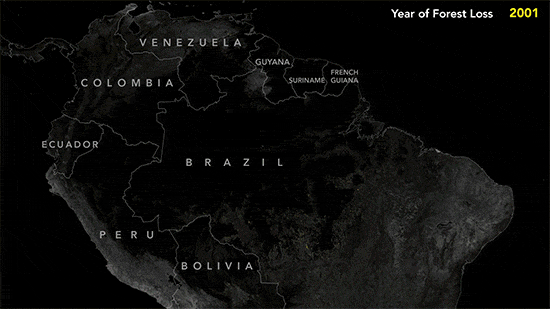
Satellite imagery’s ability to provide Earth Observation data helps increase sustainable practices through rapidly detecting deforestation, observing mining operations, locating wildlife colonies and identifying illegal activities harming the planet. Many Environmental, social, and corporate governance (ESG) collaborate with Earth Observation data to develop sustainable practices. This also allows ESG’s to minimise expenses by not having to pay field work. Even corporations are now using Earth Observation data to increase business value and optimise operations. For example; electrical utility corporations can rely on high-resolution satellite imagery to proactively monitor distribution and transmission corridors, minimising outages and disruptions.
2. Infrastructure Planning and Development
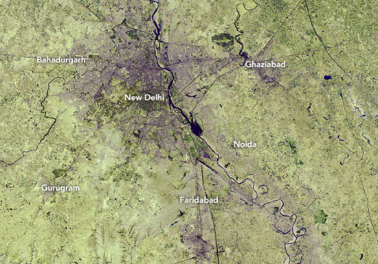
Satellite imagery collaboration can significantly help in infrastructure planning and development projects. Through collaboration, satellite imagery enables organisations to plot out surrounding landscapes and watch over the infrastructure projects full development and increasing efficiency. Additionally, urban development can greatly improve through collaborations with satellite imagery by aiding in making informed plans on where to build new housing, roads and infrastructure. Which heightens more accurate plan and infrastructure development within urban areas.
3. Insurance
Insurance companies can significantly benefit through enhancing risk assessment, claim processing and managing loss prevention. Through collaborating with satellite imagery, insurance agencies can leverage earth observation data to assess the potential natural disasters, property damage, or changes in infrastructure, optimising time and saving maximising spending. The access to high-resolution satellite images, provides better and more accurate evaluation of risk and mitigates potential losses. Moreover, collaborating with satellite imagery can aid insurance firms in post-event claims through giving visual evidence that is objective which enables quicker validation of insurance claims on a massive scale and higher reimbursement. This improves customer service, and promotes more resilient communities.
4. Humanitarian Aid and Disaster Response
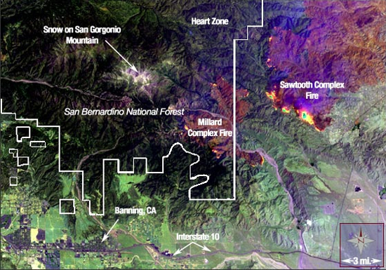
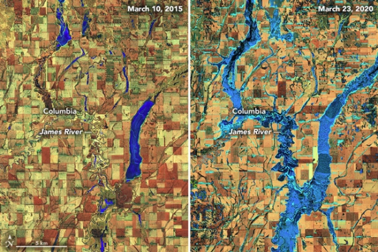
Satellite imagery has provided critical information, significantly helping response and relief efforts during disaster or humanitarian crises. By collaborating with satellite data, NGOs easily visualise areas impacted by a disaster, allowing them to verify road conditions, quickly assess the situation and plan rescue activities more effectively. In addition, agencies can collaborate with high-resolution satellite imagery to receive up-to-date images needed to compare with older ones; such as the impact of a flood. This enables organisations to identify and estimate damages, and the type of debris left from an event, highlighting efficiency and saving time and money. By combining satellite imagery with ground-based data and expertise, collaborative efforts can enhance situational awareness and support effective decision-making.

5. Fishing Industry
Satellite imagery’s ability to provide real-time, high-resolution data, enables industries like fishing to access valuable insights to better optimise operations. By collaborating with satellite imagery, fishing organisations gain access to oceanographic data, sea surface temperature maps, and fish migration patterns. Moreover, companies can monitor the activity of a fishing area – such as seeing if boats are there, and ensure certain areas are not overfished. This information can be shared to relevant authorities to better improve enforcement and in turn, improve resource management, sustainability and economic outcome.
Conclusion
Overall, satellite imagery is one of the most powerful remote sensing datasets, providing organisations with access unique actionable insight. It provides a multitude of collaborative opportunities across industries to optimise organisational operations and employ well informed decisions to drive impactful results.
More open roles
.png)

Let’s talk about how you run EO today
Most conversations start with understanding your current systems, workflows and constraints to see how Arlula can empower your team.