Leveraging BlackSky’s On Demand Satellite Imagery for Early Risk Detection and Preparedness
Rapid response is essential during emergency events. Conditions are constantly changing, impacting how emergency personnel and communities respond. In these situations, accurate and up to date information on conditions and impacts can help to maximise response and rescue efforts. In the following three use cases we will be observing the applications of Arlula’s Geostack platform, particularly the unique access to BlackSky’s large satellite constellation with its dawn-to-dusk imaging capability and rapid turn-around time, to address common natural disaster threats to the state of Queensland.
The Challenges of Conventional Monitoring and Response Techniques
Site monitoring presents numerous challenges that confront government organisations. It is inherently time-intensive, with hours spent on employees travelling to the site, collecting data, and subsequent reporting on progress and findings. Additionally, many areas that require monitoring are also remote and difficult to reach. Making acquiring data from these locations a time-consuming and inconsistent process. This prevents organisations from maintaining a complete and accurate picture for remote areas. When disaster strikes, outdated data sets inhibit efficient rescue efforts and can put responders and community members at a safety risk
Fortunately, the utilisation of on-demand satellite imagery from Blacksky and data management facilitated through Geostack Terra can improve monitoring and disaster response operations and effectively mitigate these challenges.
BlackSky
BlackSky is an invaluable provider of earth observation imagery for comprehensive monitoring purposes, providing one of the industry leading low Earth orbit small satellite constellations, which is optimised to capture imagery rapidly and cost-efficiently where and when customers need it.
With multiple satellite revisits throughout the day, from dawn to dusk, including night time imagery and a collect-to-delivery time of up to 90 minutes, BlackSky’s rapid turnaround time transcends industry standards. This detailed, near real time information enhances situational awareness and response capabilities empowering a diverse range of customers to efficiently and effectively monitor site locations and be the first to know of any changes on the ground.
BlackSky imagery is available to Geostack customers as a self-service offering with no human in the loop. Geostack Terra is a powerful tool that empowers users to efficiently and autonomously procure and manage earth observation data products from multiple sources at scale. Leveraging Arlula’s intuitive interface and BlackSky’s robust satellite constellation, this partnership accelerates progress and unlocks a multitude of opportunities for enterprises to drive growth and global impact. To take advantage of Geostack’s data management and access all that BlackSky has to offer, register your interest today.
Use Cases
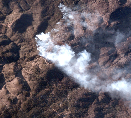
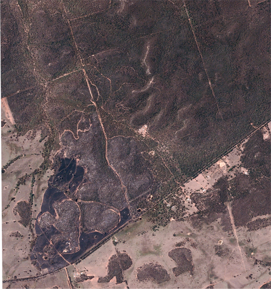
Active bushfire in NSW 8 March 2023 (Left) and a burn scar 19 March 2023 (right). © 2023 BlackSky Technology Inc
Early Fire Detection
Early fire detection is essential during the summer, especially in areas like Australia, which is preparing for El Nino as they enter into the 2023-2024 summer. Tasking imagery with BlackSky can be used with existing detection measures to improve spotting fire outbreaks early and gain situational awareness to help anticipate the threat the spreading fire has on nearby communities. BlackSky’s satellite constellation and rapid turnaround time enable one to receive high-resolution imagery within hours rather than waiting for days or weeks. This provides a resource for fire responders to locate new fire outbreaks and make well-informed rapid responses. Efficiency in early detection ultimately reduces the risks, impacts, and severity of potential fires. Continuous monitoring of fire conditions with on-demand satellite imagery also helps improve responders’ safety by providing data on the conditions of surrounding areas and tracking fire expansion.
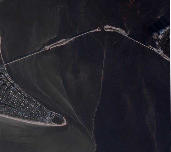
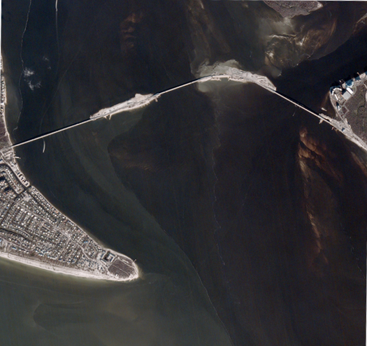
The Sanibel Causeway on 30 September 2022 (left) before Hurricane Ian hit Florida, USA and after, 26 October 2022 (right) © 2023 BlackSky Technology Inc
Cyclone Preparedness
From October through April, Queensland is susceptible to cyclones and severe storms. Cyclones bring extreme winds and flooding to the areas within its path. Early and accurate alerts are critical to ensure community safety and preparedness. When cyclones are predicted or detected, the integration of earth observation satellite imagery can help foster community preparedness and resilience. With BlackSky’s frequent revisit rate, it provides the opportunity for multiple high-quality satellite images to be captured in a day. This aids meteorologists and government officials in monitoring the trajectory of an approaching cyclone, even in hard to reach islands offshore. This effective tracking capability allows for early and accurate alerts to communities that may be at risk. As the storm passes, repeated image tasking with BlackSky offers near real-time insights into the areas affected, such as damage to housing and critical infrastructure. This dynamic monitoring enables rapid damage assessments and response, thereby expediting emergency efforts.
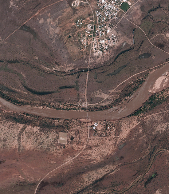
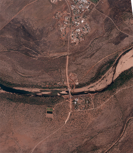
The Fitzroy River Crossing, WA experienced flooding in January 2023 (left). Recent BlackSky imagery from 13 November 2023 (right), shows the restoration progress to the damaged bridge. © 2023 BlackSky Technology Inc
Flood Risk
During the wet season, several areas around Queensland may experience flooding, as exemplified by the 2021-22 Southern Queensland Floods. In anticipation of the season, BlackSky on-demand satellite imagery can assist in conducting terrain assessments to identify drainage patterns and low-lying areas that may be at risk with increased precipitation. Cloud cover is a key feature that can be detected by BlackSky satellites. Cloud cover serves as a vital element in monitoring weather conditions, aiding professionals in identifying potential flood risks. If flooding occurs, BlackSky’s swift tasking and delivery capabilities provides responders with accurate and up to date visuals depicting the extent and impact of the flooding. This imagery proves instrumental in directing rescue efforts precisely and efficiently, minimising the potential consequences of flood disasters.
Be Prepared with BlackSky
The utilisation of high-quality satellite imagery, particularly through BlackSky’s innovative services, transcends the limitations of conventional site monitoring. Traditional monitoring and response methods are impaired by time consuming site visits, outdated information, and significant cost implications. By offering affordable, timely, and precise imagery, BlackSky empowers organisations to efficiently detect fires, prepare for severe weather, and evaluate flood risk. Together, Geostack Terra’s consolidated platform alongside BlackSky’s advanced satellite capabilities offers a swift and efficient tasking process that empowers organisations to make critical decisions faster than ever before.
*This article was updated on 24 November, 2023
Want to keep up-to-date?
Follow us on social media or sign up to our newsletter to keep up to date with new product releases and case studies.


