Multi-Site Monitoring with New Satellite Imagery
Multi-site monitoring harnesses timely and regular satellite imagery across multiple AOIs, offering a more efficient alternative to conventional monitoring practices.

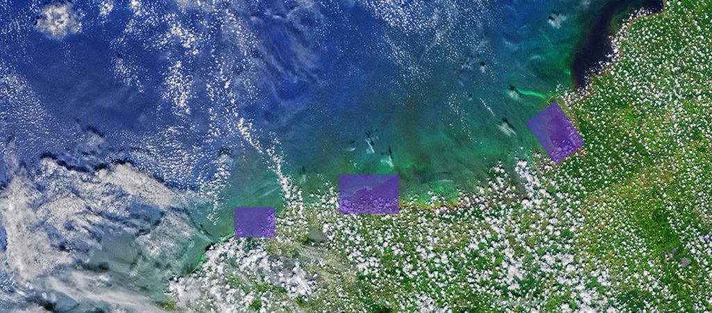
Areas of interest along Florida’s west coast during 2021 algal blooms. Captured by Landsat 8- OLI.
What is multi-site monitoring?
Multi-site monitoring is when a user has multiple AOIs that they would like to consistently capture data from. Whether you have many small sites or a few larger sites within a broader AOI, the value of new satellite imagery is immense.
Why use multi-site monitoring?
Multi-site monitoring harnesses timely and regular satellite imagery across multiple AOIs, offering a more efficient alternative to conventional monitoring practices. This approach allows the capture of imagery from multiple sites within a short period of time, ensuring both accuracy and relevance across all AOIs. Arlula’s virtual constellation employs a network of satellite operators to increase availability to users. No matter the resolution or frequency needed to meet individual requirements, there is a solution to effectively capture new imagery and monitor multiple sites. The data that is acquired from multi-site monitoring, enables users to observe, track changes, and identify patterns within multiple AOIs, ultimately enhancing decision making practices.
Example use cases:
Property Development
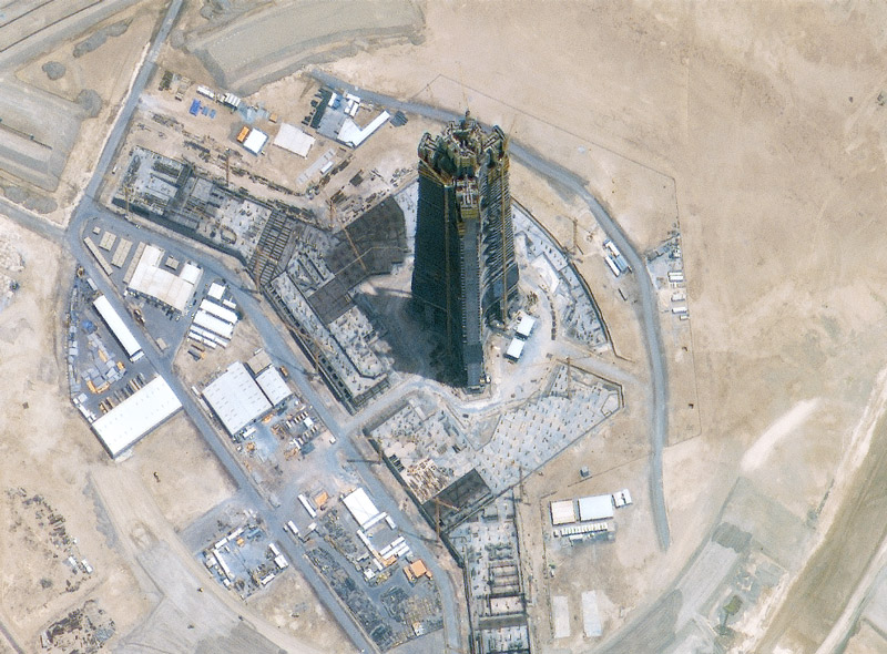
Construction progress on the Jeddha Tower. Captured by SIIS KOMPSAT 3A.
Assets
For companies that have multiple sites, conventional monitoring can be challenging. For example, a company that owns off-shore oil rigs may have them dispersed throughout a body of water, and up to 402 kilometres off the coast. Multi-site monitoring employs timely, and regular satellite imagery to provide insight over multiple AOIs. Unlike conventional monitoring practices, satellite imagery can capture a number of sites within a short period of time, ensuring that the data is accurate and relevant among all sites. This enables users to effectively assess the condition of their assets, remotely. Even the most difficult to reach areas, such as sites in the middle of the ocean, can be easily captured with on-demand satellite imagery.
Agriculture
For companies that have multiple sites, conventional monitoring can be challenging. For example, a company that owns off-shore oil rigs may have them dispersed throughout a body of water, and up to 402 kilometres off the coast. Multi-site monitoring employs timely, and regular satellite imagery to provide insight over multiple AOIs. Unlike conventional monitoring practices, satellite imagery can capture a number of sites within a short period of time, ensuring that the data is accurate and relevant among all sites. This enables users to effectively assess the condition of their assets, remotely. Even the most difficult to reach areas, such as sites in the middle of the ocean, can be easily captured with on-demand satellite imagery.
Climate
As mentioned above, the changing climate has extensive impacts. Whether it be monitoring entire coastlines or tracking multiple bushfires within remote, inland areas, multi-site monitoring is an invaluable resource. The benefit of tasking is that new imagery can be scheduled for repeated capture. Depending on satellite capabilities imagery can be captured sub-weekly, ensuring that frequent and up to date data is available for all AOIs. Regular capture can provide a base-map, or a reference map that can be layered over to help visualise changes and track patterns. Maintaining a base map is beneficial as regular capture is dependent on factors such as cloud cover and satellite capability. While these factors are inconvenient, Arlula’s vast network of providers supplies users with alternative solutions to make sure that the data is efficiently captured. Consistently monitoring multiple AOIs allows climate professionals to track changes over long periods of time, empowering decision makers to make informed responses.
Conclusion
Multi-site monitoring emerges as a pivotal tool, empowering governments and businesses alike to monitor multiple AOIs efficiently. The versatility of multi-site monitoring is evident in its application across various industries from simplifying property management to enhancing precision agriculture. Tasking satellite imagery with Arlula offers a tailored solution for capturing timely and relevant data to enhance monitoring capability and empowering informed decisions.
What is multi-site monitoring?
Multi-site monitoring is when a user has multiple AOIs that they would like to capture data from. These sites can be near each other or far away, that is one of the benefits to using satellite imagery!
What is satellite tasking?
Tasking refers to the scheduling of new imagery to be captured for future instances. Because the imagery is new, tasking allows for up to date data and images.
Who can use multi-site monitoring?
In this blog we highlighted how a few industries can use multi-site monitoring. However, anyone in any industry who has multiple AOIs could use it!
How do I include multiple sites in my search on the Catalog Browser?
When you are on the Catalog Browser, If you have a KML, WKT, GeoJSON file containing one or more polygons, you can use the File Upload Tool to select your AOIs.
More news

.png)

Let’s talk about how you run EO today
Most conversations start with understanding your current systems, workflows and constraints to see how Arlula can empower your team.