Elevating Insight: Tip and Cue with On-Demand Satellite Imagery
The Amazon rainforest is a very large area to monitor, 6.7 million square kilometres to be accurate. This is a lot of land surface for authorities & researchers to cover and monitor for deforestation or other illegal activities. This is where taking advantage of IoT and satellite networks through “Tip and Cue” strategies can help. Tip and Cue optimises monitoring over large and remote areas of interest (AOI) by coordinating sensor systems to detect and capture changes as they occur. Below, we will explore the benefits of tip and cue for use cases such as bushfire management, agriculture, and object detection.
Tip and Cue
Tip and Cue is like reading a restaurant menu. You might first skim through until you see a dish name that catches your eye. Then you will probably focus in and read the dish description to see what ingredients, flavours, and sides come with it.
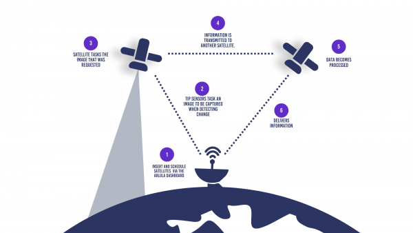
Tip and Cue acts in a similar fashion. Low resolution and wide-area IoT sensors detect something that is abnormal or of interest. This triggers a “tip” action where a complementary sensor such as a satellite is “cued” to automatically task a higher resolution image of the object or AOI. Tip and Cue is a fully automated process allowing users to receive valuable information from within a large AOI in a timely manner. This empowers industries to efficiently detect irregularities and enhances situational awareness with new, on-demand satellite imagery.
One of the main benefits of using tip and cue satellite tasking is that it enables passive monitoring and tracking within remote locations. This fully automated process empowers industries to make critical decisions in a cost-effective and timely manner.
Below, are three industry use cases where Tip and Cue has been implemented. Read on to explore the benefits of tip and cue for use cases such as bushfire management, agriculture, and object detection.
1. Bushfire
Bushfires are a common occurrence throughout Australia. Despite the devastating effects of these fires, they are an important part of the natural Australian ecosystem. However, when conditions create a favourable fire environment, it poses a health and safety risk to people. Effective fire management strategies plus prompt alert and monitoring tools can reduce the negative impacts from bushfires. When used in conjunction with existing detection technologies, tip and cue can help support emergency response teams to monitor and respond to bushfires as they occur. When smoke is detected by existing systems, automated tasking of a nearby satellite can provide responders with current, high-resolution satellite imagery of the location detected by the smoke detection sensor. This ultimately improves the response time and decision making, minimising the risk to responders and impacts on civilians.
Bushfire in New South Wales, 8th March 2023. Captured by BlackSky.

2. Agriculture
Satellite imagery has proven to be a useful tool within the agriculture industry. However, monitoring fields and crop production with repeated imagery capture may not fit every user’s data limits or budget. Tip and Cue can work with existing IoT sensors to capture new imagery only when conditions change. For example, when soil moisture changes beyond a set range, a satellite can be tasked to capture new imagery that provides a more detailed depiction of the area of interest. Tasked SAR imagery or utilising derived bands can provide timely insight into crop health and soil conditions, ultimately guiding how the condition change is addressed.
Image of flooded areas from the Red River in Minnesota, USA using NDMI. Captured by Landsat 8- OLI on 17 April, 2020.

3. Object Detection
Tip and cue has proven extremely useful in identifying objects of interest. Low resolution satellites, drones, and aerial data can detect changes in land use or identify objects such as vehicles or boats that are of interest. Higher resolution imagery can be cued to be captured over the area of object of interest to provide deeper insights for further investigation and response. AI and object recognition has played a large role in this form of detection. This ultimately reduces the need for extensive labour and financial costs, by passively monitoring and capturing detailed data of target objects when needed most.
Captured by LC-60 S1-4.

The coordinated use of sensors and satellite tasking is a useful workflow that has been leveraged by several industries thus far. Tip and cue provides a cost effective solution to derive insights and empowers users to respond quickly and effectively. This fully automated system limits the risk of false alarms, improves ability to monitor remote areas, and reduces the labour and financial costs. Want to learn more about integrating tip and cue or satellite tasking into your workflow? Get in touch with us!
Common Questions
Want to keep up-to-date?
Follow us on social media or sign up to our newsletter to keep up to date with new product releases and case studies.