Imaging Insights: A Guide to Resolution
When preparing to purchase satellite data or viewing imagery, resolution is a common term you will come across. Here, we will break down what “resolution” as a broader term means.

Since the first earth observation satellite was launched in 1972, satellite technology has consistently advanced, enabling higher quality imagery and data to be captured. One of the advancements has been resolution. When preparing to purchase satellite data or viewing imagery, resolution is a common term you will come across. Here, we will break down what “resolution” as a broader term means.
What is Resolution?
Did you know that there are 3 main types of resolutions that affect satellite imagery? Spatial, spectral and temporal resolution each play a role in how satellite imagery data can be used and can vary across each sensor.
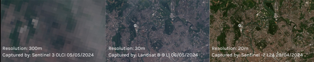
Spatial resolution comparison of imagery captured over Rome, Italy.
Spatial Resolution
When you see the term “resolution” you will most often encounter spatial resolution when working with satellite imagery. Spatial resolution or more commonly labelled as ground sample distance (GSD), is the footprint a single pixel of imagery has on the ground. For example, in an image with a resolution of 10 metres, each pixel would represent an area of 10m X 10m.
Another way to approach GSD is that it refers to the size of the smallest object that can be seen as separate from its surroundings. This means that it affects the detail of which we can identify features within imagery. Images are categorised into high-, medium- and low- resolution. The lower the GSD, the finer the detail and therefore, higher the resolution.
GSD can be affected by the satellites altitude, the off-nadir angle of capture, atmospheric conditions, signal strength, and the contrast between target features and the background.
Use Case:
Spatial resolution is the most commonly used metric for classifying optical satellite imagery. The spatial resolution needed would depend on the purpose of the imagery, the features or processes, and available budget and resources. Because of this, there is a wide range of applications within many different industries, including environment, mining, agriculture, infrastructure and more.
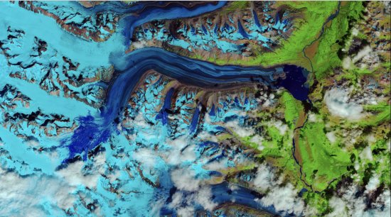
False-colour image using shortwave infrared to observe snowmelt on Lowell Glacier, Canada. Captured by Landsat-8 OLI on 26 July, 2018.
Spectral Resolution
Physical and chemical properties on the earths surface absorb, reflect, emit, and scatter electromagnetic radiation in unique ways. The resulting wavelengths of energy can be captured by satellites to create spectral images. Spectral resolution is a term referring to the difference between the maximum and minimum wavelength a sensor will register in a given band. It is most commonly used when talking about hyperspectral imaging where the width of each band tends to be similar or the same, whereas the bandwidth often differs within multispectral. Like spatial resolution, it refers to the ability to distinguish between different objects, but doing so by spectral signatures. The spectral resolution can be used to classify images as either panchromatic, multispectral or hyperspectral.
Use Case:
Spectral resolution can be used to identify features that are invisible to the human eye. Spectral resolution is an effective tool in many industries, particularly agriculture, forestry, soil, geology and land use. Higher spectral resolutions such as those of hyperspectral imagery allows for accurate mapping of minerals, identification of vegetation species, timely detection of crop diseases and more.
Temporal Resolution
Also known as revisit rate, temporal resolution is how long it takes for a satellite to complete an orbit and revisit the observation area. The temporal resolution is usually labelled as a number of days. A satellite with a higher temporal resolution can capture images of the same area in a shorter period of time (e.g. 1 day). On the other hand, lower temporal resolution takes longer for a satellite to revisit the observation area (e.g. 16 days).
Temporal resolution is affected by the satellites orbit, sensors, and swath width. Even if the satellite does not orbit directly over the area of interest, the swath width could still allow for imagery to be captured, increasing the temporal resolution.
Use Case:
Repeated captures of the same area are useful in monitoring applications. Depending on how frequently capture of the area would need to be completed, different temporal resolutions could provide daily to biweekly captures to effectively map changes in the area of interest.
Whitehaven Coal Sunnyside Mine Rehabilitation Project. Captured by Sentinel L-2A , 2019-2022.
There you have it, an overview of what resolution means in regards to satellite imagery. Spatial, spectral, and temporal resolution determine the types of information that can be derived from satellite images. Therefore, understanding resolution is crucial for anyone purchasing or utilising satellite imagery to ensure they get the most value out of their data. Want to compare resolutions on your own? Arlula’s Geostack makes it easy to customise your search with each type of resolution. Start searching today to empower your critical decisions with satellite imagery.
What is resolution?
There are 3 main types of resolutions that affect satellite imagery: Spatial, spectral and temporal resolution.
What is the difference between spatial, spectral, and temporal resolution?
Spatial: Spatial resolution is the most commonly used measurement in optical satellite imagery, and refers to the size of the smallest object that can be seen as separate from its surroundings. Often, spatial resolution is reported as ground sampling distance (GSD), or how big each pixel is on the ground.
Spectral:term referring to the difference between the maximum and minimum wavelength a sensor will register in a given band. It is most commonly used when talking about hyperspectral imaging. refers to the ability to distinguish between different objects by spectral signatures.
Temporal: Also known as revisit rate, temporal resolution is how long it takes for a satellite to complete an orbit and revisit the observation area.
Isn't high resolution the best?
The resolution you choose would depend on the purpose of the imagery, the features or processes, and available budget and resources. For example, low resolution imagery is useful in detecting abnormalities. It is a low cost tool that can lead to a more robust response. Similarly, if the value of the data lies in the type of information, such as from multiple spectral bands, rather than the overall detail of the image, low-resolution may be a better fit. On the contrary, if you need a high level of detail to identify features, for example pathogens on crops within a field, high resolution resolution may be more effective. If you are not sure what best meets your requirements, the Arlula team is glad to help.
More news

.png)

Let’s talk about how you run EO today
Most conversations start with understanding your current systems, workflows and constraints to see how Arlula can empower your team.