Why is satellite imagery useful?
Satellites have revolutionised how the Earth is monitored by providing high-res imagery from space. This makes them an essential tool in understanding and managing the planet.

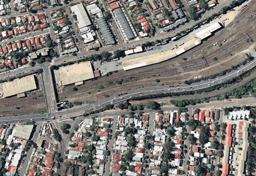
Satellites have revolutionised how the Earth is monitored by providing high-res imagery from space, making them an essential tool in understanding and managing the planet. This allows us to track changes in the environment, land use and varied ecosystems. This blog briefly explores the use of satellite imagery in various applications and its benefits for multiple industries and sectors.
- Environmental monitoring: It tracks changes in land use, deforestation, and cover to aid conservation and management decisions. Satellites monitor ecosystem health, such as wetlands, coral reefs, and forests, and detect environmental degradation or pollution. They also track wildlife movement and monitor climate change’s effects on global ecosystems.
- Agriculture: It provides farmers with info on crop growth, health and yields to optimise production, cut costs and boost yields. Satellites monitor soil moisture for effective irrigation management and detect crop pests/diseases early.
- Disaster management: In natural disasters such as hurricanes, floods and earthquakes, it assesses damage, identifies aid areas and supports response and recovery efforts. It tracks fire spread, locates evacuation routes and shelters.
- Urban planning and management: Satellite imagery helps identify areas for development, track urbanisation’s impact and monitor population density and land use.
- Security and defence: It detects potential threats and supports international agreements, tracks military forces and identifies potential targets.
- Energy industry: Satellites serve to locate potential sites for renewable energy, such as solar and wind farms, and keep track of the functioning of current energy systems. Additionally, they can spot regions with oil and gas prospects and assess the ecological effect of energy projects.
Overall, satellite imagery supports a broad range of applications, by providing accurate current and archival data to track changes across the earth. With technology advancements, it will play an even bigger role in supporting better decision making and managing the planet.
Start exploring satellite imagery from over 50 satellites via our catalog browser. Make sure to follow Arlula on social media or sign up to our newsletter to keep up to date with new product releases and case studies.
More news
.png)

Let’s talk about how you run EO today
Most conversations start with understanding your current systems, workflows and constraints to see how Arlula can empower your team.