The Impact of Monsoon Season Examined Through Satellite Imagery
Intro
In the heart of many South East Asian countries, amidst the lush fields and bustling communities, lies a scene all too familiar during the monsoon season: a farmer stands helplessly on their flooded land, surveying the damage wrought by the seasons relentless rain, distraught as the main source of livelihood now lays submerged in water.
In critical moments like these, real-time satellite imagery becomes indispensable, providing timely and precise support to first responders during rescue operations, aiding in monitoring progress in flooded areas and easy assessment to the extent of damage.
By leveraging Arlula’s platform, with its global network of top-tier data suppliers and streamlined data management processes, users can efficiently extract actionable insights at scale.Thus, in this article, we’ll showcase the invaluable role of new satellite imagery in bolstering disaster responses during the monsoon season. Additionally, we’ll delve into three satellite images depicting the impacts of the monsoon season in the Philippines, Myanmar, and Sri Lanka, and the insights it provides.
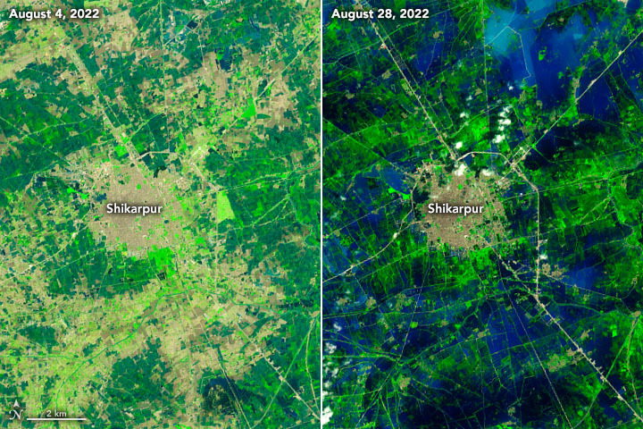
Shikarpur, Pakistan. Landsat 8 August 4, 2022 and August 28 2022.
Firstly, how does real-time satellite imagery help farmers during monsoon season?
New, on-demand satellite images play a crucial role in managing and enhancing responses during the monsoon season by providing up-to-date information on weather patterns, flood extents, and potential landslide-prone areas. This near real-time data enables authorities to make informed decisions regarding evacuation plans, resource allocation, and emergency response strategies.By pairing new satellite imagery with tip and cue, users can further heighten their monitoring capabilities as it detects and captures changes as they occur.
Additionally, high-resolution satellite images help assess infrastructure damage, identifying affected areas and enhancing coordinating rescue operations.
October 2022 Floods in the Philippines
Agriculture is a major sector within the Philippines with around 25 to 30 percent of people depending on this as a main source of livelihood. However, this industry becomes extremely vulnerable during monsoon season, with 20 tropical cyclones entering or forming within the Philippine Area of Responsibility.
In October 2022, the Philippines experienced one of the deadliest and most destructive seasons triggered by Tropical Storm Nalgae, which had affected approximately 4.8 million individuals across the Philippines. One area extremely affected by this storm was the Cotabato City in the Southern Philippines, which was submerged with flash flooding that carried rocks, uprooted trees and other sediments in and around rural areas surrounding the city.
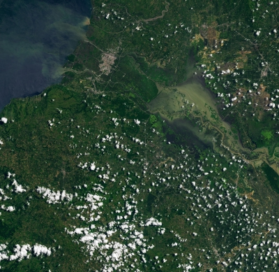
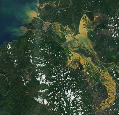
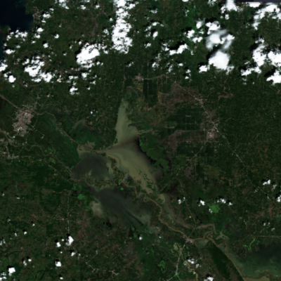
Before (L) and after (R) flooding in Cotabato City, Philippines. Captured on August 3rd, 2022, by OLI on Landsat 8 and October 30, 2022, by OLI-2 by Landsat 9.
Using two high-resolution satellite images above, we can see the extent of damage it had within Cotabato City and the surrounding areas. The floodwaters itself appear brown and discoloured due to sediment stirred up by heavy rain and floods. Plumes of sediment-laden water can be seen dispersing into Moro Gulf.
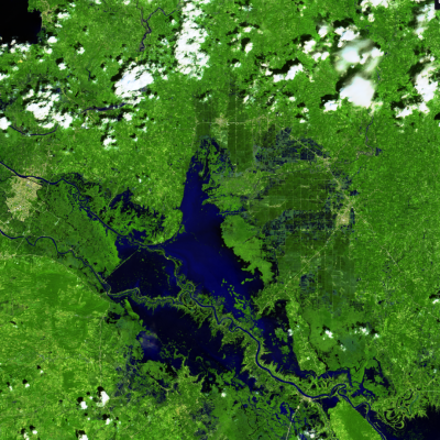
(Left) Kabuntalan Region Philippines acquired by Sentinel 2 L2A, November 12th 2022, False colour (urban). (Right) Kabuntalan Region Philippines acquired by Sentinel 2 L2A, November 12th 2022, True colour.
By utilising false colour composition, we can enhance our understanding of the aftermath of Tropical Storm Nalgae with it providing visual insights that the typical eye can’t see as seen with the images above. False colour urban composite is often used to indicate the vegetation state of the area of interest, with the shades of green indicating health, and dark blue highlighting water. Both satellite images showcase the rivers flooded in Kabuntalan region near Cotabato City post 10 days. Here we can see specks of blue on the right side, indicating the area is still submerged in flood water, whereas the true colour version is not as easy to pick up. Overall, the aftermath from Tropical Storm Nalgae left an estimated 52.8 million worth of crops damaged, placing 81,866 farmers and fisherfolk livelihoods at risk.
August 2015, Myanmar (Burma) Floods
In Myanmar, agriculture is the main source of livelihood, with it accounting for around 60 percent of the GDP and employing around 65 percent of the labour force. Given that agriculture is a significant contributor to the economy, the onset of the monsoon season can bring stress and apprehension to farmers in Myanmar. According to the International Food Policy Research Institute, 27 percent of farmers experience feelings of being ‘unsure’ during this period, highlighting the vulnerability of agricultural livelihoods to the uncertainties of the monsoon rains.
In early August 2015, Myanmar was faced with widespread flooding caused by the combination of monsoon weather and rain from the wake of Cyclone Komen. Over one million people were affected by these floods, 1.29 million acres of farmland was inundated and 687,200 acres of farmland damaged.
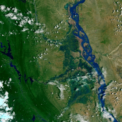
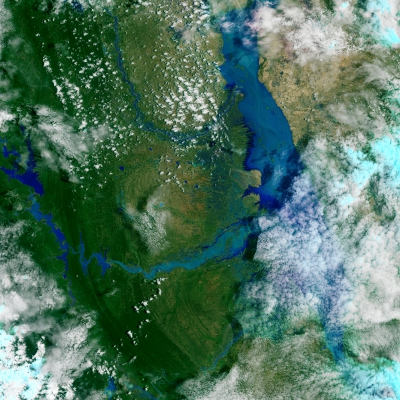
(Left) Irrawaddy River, Magway Region of Burma (Myanmar), acquired August 29, 2013 by landsat 8 OLI. (Right) Irrawaddy River, Magway Region of Burma (Myanmar), acquired August 3, 2015 by landsat 8 OLI.
Areas that surrounded the Irrawaddy River, Myanmar’s second largest river, were found to be severely affected. In the above satellite images. The right hand side satellite image, captured in August 2013, showcases the river when it is on a normal level. The second satellite image on the left, captured in August 2015, demonstrates the flooded effects of Irrawaddy River.
Through applying false colour and zooming into both satellite images, we can enhance our understanding of the areas which were impacted. We can see that the areas that have reddish hues, (which indicate more urban and agricultural areas), have been engulfed by the flooded river. Overall, half of all losses found in agriculture, with more than 250 thousand livestock were lost.
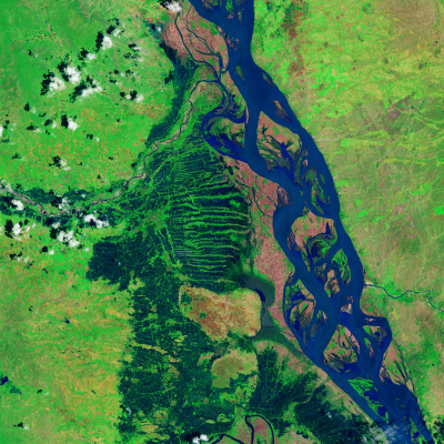
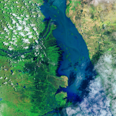
False colour images of Irrawaddy River, Magway Region of Burma (Myanmar). Acquired August 29, 2013 by landsat 8 OLI (Left) and August 3, 2015 by landsat 8 OLI.
May, 2017 Sri Lanka Floods
In Sri Lanka, the agriculture sector is a vital component of the economy with over 30 percent of Sri Lankans employed in agriculture and more than 40 percent of the land dedicated to farming. However, Sri Lanka’s agriculture sector is significantly vulnerable to climate related disasters.
This is further heightened as the country experiences two distinct monsoon seasons: the Maha (October to January), affecting northern and eastern areas, and the Yala (May to August), influencing the southern and western regions. While the monsoon seasons provide essential rainfall for crop growth, they also bring the risk of severe storms that can cause significant damage to crops. Climate change exacerbates these impacts, with projections suggesting that Sri Lanka’s wet zones will become wetter while dry zones become drier, directly affecting agricultural activities in both regions.
Its devastating impacts can be seen in May 2017 between the 25th to the 26th, where Sri Lanka saw one of the country’s worst rainfall events since 2003. Catalysed by heavy rain and high winds brought about by the southern monsoon, over half a million people with 15 out of the 25 districts were affected by severe flooding and landslides. Populations within the Southern and Western Provinces; particularly Rathnapura, Matara, Hambantota, Kalutara and Galle districts experienced the highest impact.
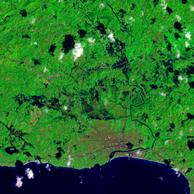
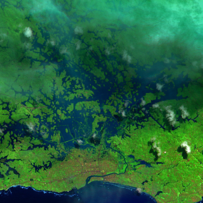
False colour images of Matara, Sri Lanka. Acquired January 29, 2017 by Landsat 8 (Left) and May 28, 2017 by Landsat 8.
We can further see the impacts of these floods on Matara, with the province close to the Nilwala River which overflowed.On the left side, captured on January 29 2017, by Landsat 8, we can see the By examining the satellite imagery above, we can see the Southern Province prior to the floods. On the right, is a satellite image captured on May 28, 2017 where we can see several areas around the Nilwala Ganga River fully submerged. Both the satellite images use Infrared lighting to further distinguish the presence of water on the ground. Matara can be seen just below highlighted by the grey and reddish area near the bottom of both images.
Due to the floods and landslides, Matara’s livestock sector was mainly affected, with the highest impact recorded with cattle, swine, buffalo, goat and poultry sectors. Overall the agriculture sector saw a total loss of 84.63 USD, with all lowland cultivations submerged for a considerable duration during the May 2017 floods.
Want to keep up-to-date?
Follow us on social media or sign up to our newsletter to keep up to date with new product releases and case studies.


