Why Satellite Imagery is a Game-Changer for Agriculture
Satellite imagery is revolutionising the agricultural industry, providing farmers with real-time data and insights to help them make better decisions about monitoring crops and land.
When you think of agriculture, your first thought probably didn’t land on satellite imagery. However, for many in the agricultural industry, the use of high-quality satellite imagery has been a game-changer!
Since its creation, satellite imagery has been one of the most powerful tools to monitor the Earth, providing farmers the ability to greatly enhance their monitoring capabilities in areas such as crop health, identification of pests and disease and soil moisture levels. This information is crucial, helping farmers and those within the agriculture industry to optimise their inputs, reduce costs, and increase yields.
In this blog, we will highlight the benefits of satellite imagery for the agriculture industry.
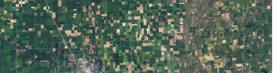
Farm fields in Minnesota, USA. Captured by Landsat 5 on 10 September, 2009.
Example 1: Crop Monitoring
High resolution satellite imagery is a valuable tool in crop monitoring by providing farmers with a comprehensive and timely view of their crops. As satellites capture images of a field over a period of time, farmers are provided vital information such as vegetation indices like NDVI which enhance the monitoring in areas like soil moisture, canopy density and chlorophyll content . This allows one to identify and address problems early on, such as pests and diseases, nutrient deficiencies, and water stress. With a recent report by the United Nations Food and Agriculture Organisations, finding that farmers which use satellite imagery to monitor crops have an average yield increase of 12% highlights how beneficial satellite imagery is to farmers and those within the agriculture industry.
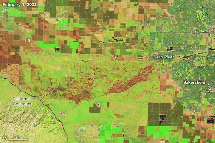
Flooded Ponds in California, USA. Captured by Landsat 8 on 1 February, 2023 and by Landsat 9 on 30 April, 2023.
Example 2: Water Management
Satellite imagery provides a plethora of data to help farmers understand and manage their water indices. For example, satellite imagery can monitor water levels in lakes and reservoirs, track mountain snowpack levels, and map coastal erosion. This information can be used to forecast water availability, develop water management plans, and protect communities from flooding. Satellite imagery can also identify water quality issues, such as agricultural runoff or industrial waste pollution. This information can be used to develop strategies for improving water quality and protecting human health.

Example 3: Yield Forecasting
Satellite imagery has a significant impact on the estimation and forecasting of crop yield through its ability to measure a variety of crop parameters such as normalised difference vegetation index (NDVI), leaf area index (LAI), and land surface temperature (LST). Enabling farmers and those within the agricultural industry to make more informed decisions across their inputs, irrigation and marketing efforts. Additionally, the use of satellite imagery as a tool to monitor yield forecasting, is incredibly advantageous in comparison to traditional methods of yield forecasting. Satellite imagery is found to be more timely, cost-effective and comprehensive than these conventional methods, with it being able to forecast yields for large areas, which is impossible with traditional methods. NASA Harvest has proven its ability to generate crop maps over larger heterogeneous areas. Through harnessing satellite imagery from Sentinel-2, NASA-USGS Landsat, and Planet’s SkySat, and applying machine learning algorithms, NASA Harvest produced a cropland map within 10 days upon request from the Togolese Government. This map swiftly and accurately assisted authorities in identifying priority areas for their relief programs.
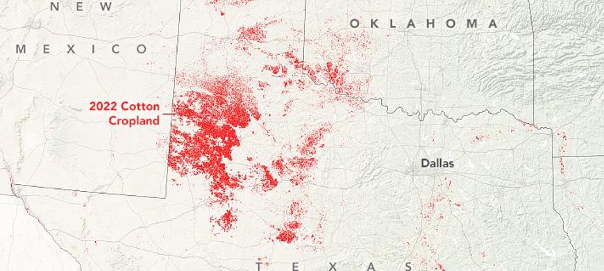
Map of cotton-growing areas in Texas, USA using data captured by Landsat 8, ResourceSat-2 and Sentinel-2 Landsat 9 in 2022.
Example 4: Pest Detection
Pest are a common problem for farmers with around 20% to 40% of global crop production lost due to pests annually. Invasive insects and species cost around $70 billion globally in losses.
Satellite imagery can mitigate and improve pest control for those within the agriculture industry by providing timely and comprehensive data on pest outbreaks and crop health. For example, farmers can use satellite images to identify areas of their fields where pest infestations are most severe. This allows them to target those areas with specific pest control measures, such as precision spraying of pesticides or deploying pest-resistant crop varieties.
Currently, the United States Department of Agriculture (USDA) uses satellite imagery to monitor the spread of invasive pests and diseases, such as the Asian citrus psyllid and the emerald ash borer. The USDA also uses satellite imagery to assess the effectiveness of pest control programs.
Overall, satellite imagery is a powerful tool for pest control. It can help pest control professionals and farmers detect pests early, track their spread, and assess the effectiveness of control measures. This information can be used to develop more effective and sustainable pest management strategies.
Looking to Improve Your Monitoring Capabilities with Satellite Imagery?
At Arlula, we provide a single access point to allow users to procure, manage and process satellite imagery at scale. Easily obtain decades of satellite imagery from around the world to help make critical decisions. Search, order and save on high resolution imagery from a range of free and commercial satellites on demand and at scale via our API.
What does satellite imagery do for the agriculture industry?
Satellite imagery helps improve optimisation for the agriculture industry by providing farmers with timely and comprehensive data on crops, land, and weather. This data enhances decision-making across the supply chain, from planting to harvesting.
Additionally, satellite imagery helps farmers to reduce costs, increase yields, and improve the sustainability of their operations. Interested in optimising your business with satellite imagery?
What is the most common use of satellite imagery for the farming industry?
Crop monitoring is the most common use of satellite imagery for the farming industry. Satellite imagery can monitor crop growth and development, identify pests and diseases, and assess crop health. This information can be used by farmers to make informed decisions about irrigation, fertilisation, pest control, and other crop management practices.
How accurate is satellite imagery?
The accuracy of satellite imagery depends on a number of factors, including the sensor used, atmospheric conditions, and ground resolution. In general, satellite imagery is very accurate, with high-resolution imagery having an accuracy of within a few metres. However, accuracy can be reduced by atmospheric conditions and the type of sensor used.
How can satellite imagery be used to improve agricultural forecasting and planning?
Satellite imagery is a powerful tool for improving agricultural forecasting and planning. It can be used to monitor crop growth, forecast yields, assess drought risk, and plan land use. This information helps farmers make better decisions about resource management and mitigate crop failure risk.
How can satellite imagery be used to support sustainable agricultural practices?
Satellite imagery helps support sustainable agricultural practices by providing real-time and historical data on crop growth, health, and land use. This then helps farmers make better decisions about resource management and mitigate the risks of crop failure thus contributing to a more sustainable and food-secure future.
More open roles
.png)


Let’s talk about how you run EO today
Most conversations start with understanding your current systems, workflows and constraints to see how Arlula can empower your team.